|
|
|
ITINERARIO GAETA - FORMIA – MARANOLA – MONTE REDENTORE – TRIVIO - CASTELLONORATO – SPIGNO SATURNIA – SCAURI - MINTURNO - SS.COSMA E DAMIANO – CASTELFORTE – SUIO TERME
Torna all'elenco
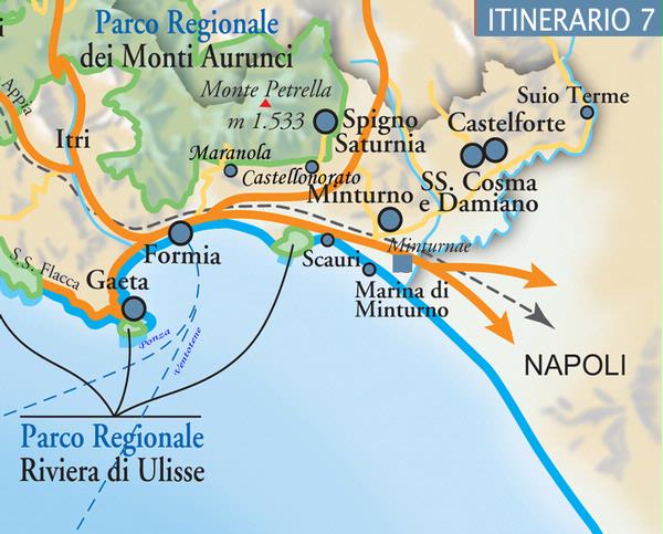 Moving inland, it is possible to visit MARANOLA at the foot of Monte Altino, a village whose position enables views over the entire gulf. In the medieval centre, we can see the remains of a castle, a rectangular tower and the churches of S. Maria ad Martyres and S. Luca. The village lies on a steep road up Monte Redentore (1250 metres above sea level), a mountain which takes its name from the statue of Christ located on its summit in 1901. At the foot of the mountain, after a visit to the rocky sanctuary of S. Michele Arcangelo, through the hamlet of Trivio we reach CASTELLONORATO, a village which takes its name from the castle built by Onorato I Caetani on the road to Cassino. Castellonorato offers excellent views over the Gulf. Returning to Formia and taking Via Appia to S. Croce, we find SPIGNO SATURNIA. The original centre of Spigno Vecchio, now more or less abandoned except in summer; and the new village of Spigno Nuovo which lies on the Formia-Cassino highway. In the older part of the village, much of which was destroyed in the second world war, are the ruins of the city wall at Campovivo and an ancient castrum. The village lies on the slopes of Monte Putrella, the highest peak in the Aurunci mountain range at 1553 metres above sea level, whose freshwater springs – and especially the Capodacqua spring - supply all the neighbouring villages. The religious buildings include the church of S. Croce. From Spigno Nuovo, on the Formia-Cassino highway and heading towards the sea on the Via Appia, we may visit SCAURI, in the municipality of Minturno which, together with MARINA DI MINTURNO, stretches the length of coast from Monte d’Oro to Monte d’Argento. In addition to the defensive towers which can still be seen on the cliffs, in Scauri it is also possible to see a stretch of city wall. Monte d’Oro also marks the beginning of the Giànola-Monte di Scauri, with the Oasi Blu, a natural reserve which is part of Riviera di Ulisse regional park. Heading inland towards MINTURNO, whose centre develops around Corso V. Emanuele, we find important monuments: the baronial castle, the Palazzo Municipale (a former monastery), the 13th century collegiate church of S. Pietro and the churches of S. Francesco and Annunziata as well as a fine Exhibition of Traditional Dress and the World of Agriculture. The territory of Minturno extends as far as the southern border of the province of Latina, which is marked by the River Garigliano, over which a 19th century chain bridge leads to the province of Caserta. On the provincial border lies the Roman archaeological area of Minturnae, with a stretch of the original Via Appia, the ruins of a Republican Forum, an Imperial Forum, a bathing complex, a macellum, an amphitheatre (in which summer theatre seasons are organized), and an antiquarium. Next to this ancient Roman city lies the British Military Cemetery (Second World War). On the other side of the street are ruins of a Roman aqueduct. The delightful hillside hamlets of S. Maria Infante, Pulcherini and Tufo are also worthy of a visit. Ten km inland from Minturnae lies the hillside village of SS. COSMA E DAMIANO which, together with the neighbouring municipality of Castelforte, commands a fine view over the plain of the River Garigliano. Although completely destroyed in the terrible bombings of the second world war, it still shows Palazzo Tibaldi, the churches of SS. Cosma e Damiano and of S. Lucia. Above the village, in the hamlet of Ventosa, there is a beautiful medieval tower. CASTELFORTE is the most southern municipality in the province of Latina, on the border with the region of Campania, from which it is separated by the River Garigliano, the village still retains its original medieval layout. The most important monuments are the city walls, the Santa and Cianca gates, the square tower and the church of S. Giovanni Battista. Older still is the hamlet of SUIO ALTA, with the ruins of a small castle, while just below the village lies the disused country church of S. Maria in Pensulis. Along the banks of the River Garigliano lies SUIO TERME, a natural spa which has been famous since Roman times for its therapeutic waters (aquae vescinae) - perfect for water therapies, irrigations, inhalings and insufflations – and mud. |
|
La Riviera d'Ulisse - Ente Turistico di Terzo Settore
Servizio IAT - Informazione ed Assistenza al Turista Largo Jacopo Peri, 70 - Latina - tel. 0773480672 - 0773484502 - 06/69281723 www.larivieradulisse.it - www.larivieradulisse.it - www.latinaeventi.it - info@latinaturismo.it a cura di Cooperiamo Insieme Cooperativa Sociale P.I. 02812020598 |
|
powered by iper.net |
|
